 Photography by Cody Tracy
Big Basin Prairie Preserve
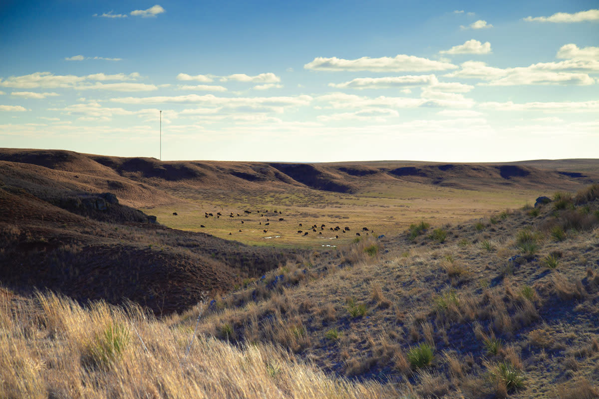
If you’ve been here, you know. If you haven’t, make it a priority. With sweeping grasslands and endless skies, Big Basin Prairie Preserve is more than 1,800 acres of roadtrip-worthy beauty. It has natural attractions—bison—that can be seen throughout the year, and a scenic trail allows you to access and appreciate the landscape’s most spectacular views.
The preserve lies in the Red Hills region of Kansas, also known as the Gyp Hills, an oxidized, gypsum-rock landscape with rolling hills, scalable canyons and intermittent water sources. One mile across and 100 feet deep, Big Basin is a bowl-shaped expanse of rock sediment, native grass, and shallow pools. Canyon walls rise straight from the basin and are tufted with yucca, native wildflowers, gypsum, and limestone sediments.
The basin was formed by a geologic process that caused a gradual, gentle sinking of the land’s surface. In this process, surface water leaked into the ground and dissolved gypsum, limestone, and salt formations. Minerals filled in the vacated spots, creating a unique geologic landscape of buttes and plateaus.
St. Jacob’s Well
St. Jacob’s Well sits just west of Big Basin in an area known as the Little Basin, a natural sink some 300 yards in diameter that drops 35 feet to a pool of water surrounded by stark white rock formations and cottonwood trees.
Ashland native Michael Gillaspie shares a childhood experience during a Cub Scout expedition. “We hiked down to St. Jacob’s Well and saw a place that seemed like an oasis. Our 7-year-old imaginations went wild when we heard about the legends.”
These local legends spin that the strikingly indigo pool is bottomless and filled with blind fish. Other sources claim that a spectral cowboy haunts this land and that the site has never gone dry, so settlers were always able to graze and water their horses. According to other stories, divers have tried—and failed—to reach the bottom. Gillaspie adds, “I came back to see it thirty years later, and the kid in me still wants to know—has anyone seen the bottom of Jacob’s Well?”
Scientific data indicates that the funnel-shaped pool is approximately 58 feet deep, but the precision of the measurement does nothing to dampen the mysterious beauty of the scene.
Getting there
Big Basin Prairie Preserve is in Clark County in southwest Kansas, some fifteen miles south of Mineola, tucked off Highway 283/US-160, but it’s not readily visible from the road. Because the Big Basin Prairie Preserve can easily elude passersby, be sure to turn on the GPS, or go old-school with a paper map to find the short gravel turn-off and, for the love of Kansas, stop!
Once you have parked off the road, look for the trail. Although it is not identified on many trail locator apps, the rugged gravel path starts at the historical marker near the highway and winds for 1.7 miles through prairie expanse and endless sky to the summit.
To get to St. Jacob’s Well, go south from the Big Basin turnoff along 283/160 for approximately a mile then turn west on the parallel road, which will run back north and take you to a cattle guard and a gravel road that runs just over 3 miles to Little Basin and the well.
Managed by the Kansas Department of Wildlife and Parks, both areas are open all year to respectful visitors. Vehicles are allowed on the gravel trail. Foot traffic is welcomed and encouraged on the path, and visitors who make the slow climb will often be rewarded with sightings of the free-roaming bison herd off in the distance on either side. Of course, if traveling inside a vehicle or by foot, follow sensible precautions not to agitate or interact with the bison.
I recommend driving to the summit and then parking there for further exploration by hiking, running, or walking. Avid trail runners should consider running down and back to the highway for a rise over 2,300 feet. Whichever mode you choose, plan on spending several hours to appreciate the opportunity for reflection and scenic photography.
If you spend the day at the Basin, you might want to consider overnight lodging in Dodge City, which is only 40 minutes to the north.
Quick Facts
Location: Ashland/Englewood region of Clark County
Trail Distance (Big Basin): 1.7 miles from the highway to crest; out and back
Rating: Moderate to difficult
Terrain: Coarse gravel
Surrounding Attractions: Gypsum Hills Scenic Byway | Dodge City | Clark County State Fishing Lake
Hunting: No
Facilities: No
Camping: No
READ MORE
Hidden Hiking Gems: Lehigh Portland Trails
Hidden Hiking Gems: Three Lesser-Known Hikes
Ways to Stay Connected
More Outdoor Articles You'll Enjoy
View ALlKansas' River Adventures
Jun 25, 2024Photo Credit: David Mayes Adventure awaits in the untamed beauty of Kansas' three navigable… Read More
High Plains Under the Sea
Jun 24, 2024Photo Credit: Meg Kumin An ancient sea and the life that thrived in it shaped the contour of the… Read More
The Kansas Wetlands
May 28, 2024Two neighboring wildlife areas in central Kansas offer some of the nation’s best viewing for… Read More
Native Grasses in Kansas
May 28, 2024Save money and the planet with these backyard grasses The subtle beauty of dusk is one of the best… Read More
Botanical Gardens Light Up for the Holidays
Nov 29, 2023Imagine strolling down candlelit paths through tranquil, snow-covered woods as the stresses of the… Read More


